Lake Erie Trolling Guide: Thermocline, Walleye Migration & Summer Depth
Lake Erie trolling is largely about finding the right part of the water column.
For much of the summer, one of the most useful things to understand is the thermocline. It can help explain where walleye are suspended, where baitfish are holding, and why productive trolling depths can change through the season.
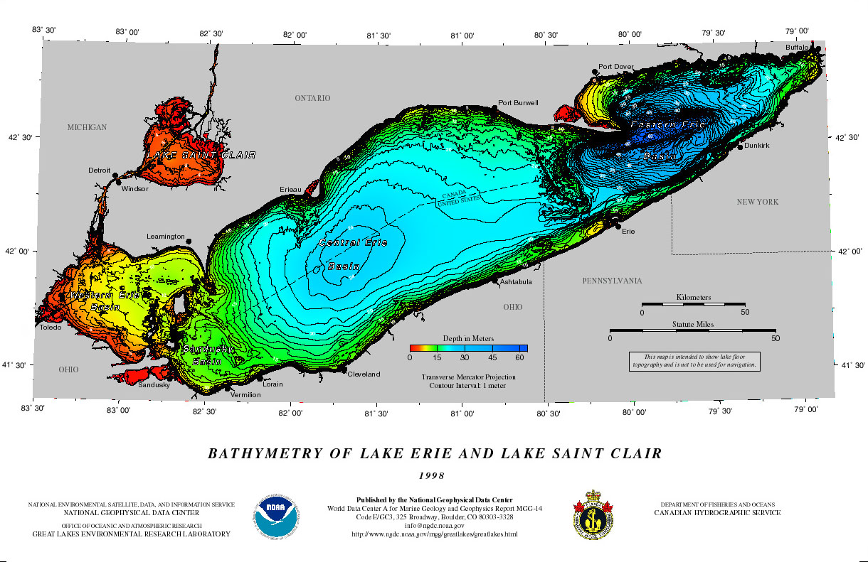
Lake Erie is also different from the other Great Lakes. Its western, central, and eastern basins have very different depths, and walleye make major seasonal migrations across the lake.
The Great Lakes Trolling map lets you see temperature at different depths, locate the thermocline, inspect the full water-column temperature profile, check waves and currents, and see how conditions are forecast to change.
Open Lake Erie on the interactive map
Lake Erie has three very different basins
Lake Erie is the shallowest Great Lake overall, but its depth changes considerably from west to east.
| Basin | Average depth | Maximum depth |
|---|---|---|
| Western Basin | About 24 ft / 7 m | About 62 ft / 19 m |
| Central Basin | About 60 ft / 18 m | About 82 ft / 25 m |
| Eastern Basin | About 80 ft / 24 m | About 210 ft / 64 m |
The western basin is shallow enough that wind frequently mixes much of the water column. Stratification can occur, but it is usually less persistent.
The central and eastern basins develop much stronger summer temperature layering. That is where understanding the thermocline becomes especially useful.
What is the thermocline?
The thermocline is a temperature phenomenon.
As Lake Erie warms during summer, warmer water remains near the surface while colder, denser water stays below.
This creates three general zones:
- Epilimnion: warmer water above the thermocline
- Thermocline: the transition where temperature falls rapidly with depth
- Hypolimnion: colder water below the thermocline
Lake Erie’s summer currents and thermocline
Summer winds can drive a strong clockwise current around the central basin. Researchers found that the thermocline can form a bowl shape—deeper in the middle of the lake and shallower near shore, opposite the more familiar dome shape. This can squeeze the cold water near the lakebed and may contribute to low oxygen in the central basin.
Why the thermocline matters for walleye
The thermocline creates a useful reference point for suspended fish.
Walleye may hold above it, within it, or sometimes below it. Baitfish can also concentrate around the temperature break.
For walleye, I generally start around the top of the thermocline or a foot or two above it.
For example, if the thermocline begins around 40 feet, I might initially cover:
35, 38, 40, 42, 45 ft
Then I let my electronics and actual bites determine where the rest of the spread should go.
The important part is not to treat the thermocline as a hard boundary.
If your sonar shows walleye at 30 feet, fish 30 feet.
If bait and large marks are below the thermocline and oxygen conditions allow fish to use that water, fish below it.
The thermocline narrows the search. Your electronics finish the job.
Walleye, smelt and the thermocline
The thermocline becomes especially interesting when forage is involved.
Rainbow smelt prefer relatively cold water and are frequently found around or below the thermocline.
Walleye can position near the upper portion of the thermocline and move into the colder water to feed.
This can produce a situation where bait is below the temperature break while walleye are concentrated near its upper edge.
That is one reason trolling the top of the thermocline can be so productive.
But nothing is carved in stone.
Bait location, oxygen, weather, light, season, and fish movement can all change where walleye are actually holding.
The thermocline is not the oxygen line
You will sometimes hear the thermocline described as the lower limit of oxygenated water.
That is not quite correct.
The thermocline is defined by temperature, not oxygen.
However, stratification can eventually affect oxygen levels.
Water above the thermocline is regularly mixed with the atmosphere.
Water below it is more isolated.
As organic material sinks and decomposes, the process consumes dissolved oxygen. Because the upper and lower layers are not mixing efficiently, that oxygen is not replaced quickly.
Over time, the hypolimnion can develop what is sometimes called an oxygen debt.
This does not happen the moment a thermocline forms.
Fish can still occupy water beneath the thermocline while oxygen remains adequate.
That distinction is particularly important on Lake Erie.
Central Lake Erie and low oxygen
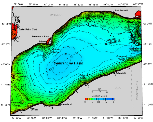
The central basin is relatively shallow and flat.
When it stratifies, the cold hypolimnion underneath the thermocline can be quite thin.
That relatively small volume of cold water has a limited supply of dissolved oxygen. As summer progresses, decomposition can gradually consume it.
By late summer, parts of the central basin regularly develop hypoxic water, generally defined as dissolved oxygen concentrations of 2 mg/L or less. EPA monitoring has repeatedly documented these conditions during August through October.
This can reduce the amount of usable habitat beneath the thermocline.
Walleye may concentrate near the thermocline while cold-water forage such as smelt occupies cooler water nearby.
As oxygen continues to decline, baitfish and predators may both be pushed upward.
However, do not assume that everything below the thermocline is automatically unsuitable.
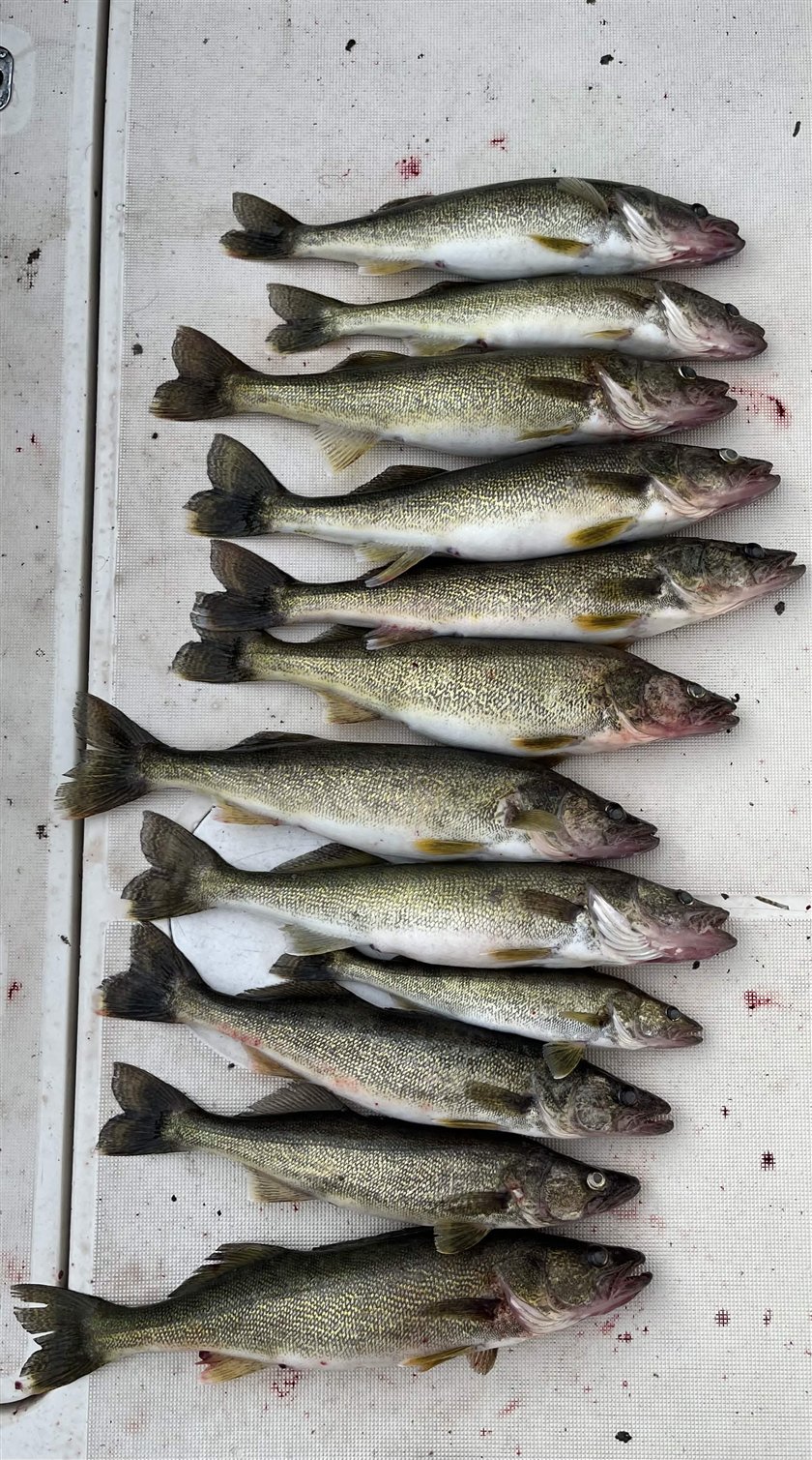
Early in the stratified period, there may still be plenty of oxygen underneath it. Large walleye can sometimes be caught close to bottom even with a well-defined thermocline much higher in the water column.
Fish what your electronics show you.
Eastern Lake Erie is different
The eastern basin is much deeper.
Its hypolimnion contains a much larger volume of cold water, so it has a much larger oxygen reserve than the central basin.
Oxygen still declines below the thermocline through summer, but severe oxygen depletion is generally not the same problem that it is in the central basin.
That means fish can make much greater use of the cold water below the thermocline.
Lake trout are a good example.
When targeting lake trout, I generally look toward the lower part of the thermocline and the cold water underneath it.
Steelhead can also relate to the thermocline and suspended forage.
Again, these are starting points.
Where you actually see bait and fish on your electronics should dictate the final depth.
Lake Erie walleye migration
Depth is only part of Lake Erie walleye fishing.
You also need to understand that the fish themselves are moving across the lake.
Large spawning populations occur in western Lake Erie. After spawning in spring, many of those walleye leave the shallow western basin and migrate toward the cooler central and eastern portions of the lake.
NYSDEC notes that these western migrants can number in the millions and combine with local eastern Lake Erie walleye populations to produce the summer fishery there.
Telemetry studies have documented seasonal movements exceeding 400 km, although individual fish and different spawning populations do not all follow identical migration patterns.
Spring
During spring, much of Lake Erie is still relatively well mixed.
A strong, persistent thermocline may not exist yet.
Walleye are heavily influenced by spawning and post-spawn movements.
Large numbers of fish are concentrated around western Lake Erie spawning areas, while Lake Erie also contains local spawning populations elsewhere around the lake.
After spawning, fish begin dispersing.
At this time of year I would place more emphasis on:
- spawning and post-spawn movements,
- water temperature,
- reefs and structure,
- water clarity,
- and bait.
Early summer
As surface water warms, the central and eastern basins begin to stratify.
At the same time, many walleye are moving offshore and eastward.
This is when trolling becomes increasingly focused on suspended fish rather than simply fishing near bottom.
Start checking temperature at several depths and watch for the thermocline beginning to develop.
Mid-summer
By mid-summer, the thermocline can become one of the most useful pieces of information available to a Lake Erie troller.
This is the time to pay close attention to:
- the top of the thermocline,
- suspended bait,
- suspended walleye,
- and the depth where you are actually getting bites.
For walleye, I generally begin around the upper thermocline and spread a few presentations above and below it.
Then tighten the spread once a pattern develops.
Late summer
By late summer, the thermocline is well established in the central and eastern basins.
In the central basin, dissolved oxygen below it becomes increasingly important.
Cold bottom water is not automatically good fishing water if oxygen has fallen too low.
The eastern basin is different because its deeper hypolimnion generally remains much better oxygenated.
That allows cold-water fish to continue using depths well below the thermocline.
Fall
As air and surface-water temperatures fall, the upper layer of Lake Erie begins cooling.
Eventually the temperature difference between the upper and lower layers becomes small enough that the lake mixes again.
The summer thermocline weakens and eventually disappears.
At that point, bait, structure, seasonal movement, and broader water-temperature patterns become more important than locating one particular temperature break.
Lake Erie currents matter when trolling
I was wrong to downplay them. Central Lake Erie can develop substantial wind-driven circulation in summer. The current's direction and strength can vary by basin, depth, and weather, so surface flow may not match what your lures experience.
Current changes lure speed and action, trolling direction, downrigger cable angle, and how divers track. GPS measures speed over ground, which can differ from lure speed through the water. Compare currents near the surface and at your target depth, try both trolling directions, and adjust based on lure action and bites.
Upwelling and downwelling
Once Lake Erie becomes stratified, strong or sustained winds can move the thermocline substantially.
Upwelling brings colder deep water toward the surface or shoreline, while downwelling pushes warm surface water deeper and forces the thermocline down.
For anglers, this can quickly change productive trolling depths. A depth that held walleye before a strong wind may contain completely different water afterward as bait and predators move with the temperature structure.
In the central basin, late-summer upwelling can also bring cold, low-oxygen water toward shore. Fish may be forced out of this water and concentrated along its edges. In severe cases, oxygen levels can become so low that fish are unable to escape, contributing to localized fish kills.
Wind direction matters because the same wind can produce upwelling on one side of the lake and downwelling on another.
View current Lake Erie upwelling and downwelling
A simple Lake Erie trolling checklist
Before leaving the dock:
- Check waves and weather. Start with safety and use official marine forecasts and warnings.
- Know which basin you are fishing. The western, central and eastern basins behave differently.
- Find the thermocline. Look at the water-column temperature profile and identify where temperature begins falling rapidly.
- Build your starting spread around it. For walleye, begin around the upper thermocline. For trout, investigate the lower thermocline and colder water below it.
- Find bait and fish on your electronics. If your sonar disagrees with your prediction, believe your sonar.
- Let bites refine the spread. Once one depth repeatedly produces fish, move more presentations into that zone.
Open Lake Erie on the Great Lakes Trolling map
Sources
- New York State Department of Environmental Conservation: Walleye Fishing on Lake Erie
- U.S. Environmental Protection Agency: Lake Erie Water Quality Data
- U.S. EPA: Lake Erie
- NOAA: Bathymetry of Lake Erie and Lake St. Clair
- NOAA National Centers for Coastal Ocean Science: “Lake Erie’s ‘Backwards’ Circulation Explained”
- Beletsky et al. (2012), “Summer thermal structure and anticyclonic circulation of Lake Erie,” Geophysical Research Letters
- U.S. Geological Survey: research on seasonal migration and temperature use by Lake Erie walleye
- Great Lakes Fishery Commission: Lake Erie fisheries research and assessment